King Mountain Weather Station
Special thanks to Dennis Latyshev for setting up a weather station at King!
King Mountain Weather Station
Soaring Weather at King Mountain
 by John Kangas – volunteer “Weather Guru” King Mountain Hang Gliding Championships
King Mountain is located in a high semi-arid desert region of eastern Idaho near the Montana border and the Continental Divide. Averaging less than 10 inches of year, this region of the Rocky Mountains has four distinct seasons with winter temperatures reaching well below freezing and summer highs into the 90s (35c). The Weather is influenced by deserts stretching as far as Mexico to our south, and Alpine regions to our north. At almost 44 degrees north latitude, King Mountain is half way between the Equator and the North Pole. This Article will showcase 3 distinct soaring seasons, local weather phenomenon, and a brief yet important section devoted to physiology.
The Spring Soaring Season

Soaring at King Mountain begins in April with winter snow still blanketing the mountain ranges. Cold nights and powerful solar heating during the day time kick start our soaring adventures into high gear with strong punchy thermals. Highs can approach the upper 60s and lows will still be near freezing. Spring in the Rockies is marked by Pacific Cold Fronts moving through in 24 to 48 hour intervals. These cold fronts generally exhibit the standard northern hemispheric characteristics of warm southwesterly wind flows aloft prior to the front, and colder northwesterly winds both aloft and on the surface after frontal passage. Even with the cooler temperatures, cumulus cloud bases at 12,000’ to14,000’ feet are not uncommon in the spring time at King Mountain.
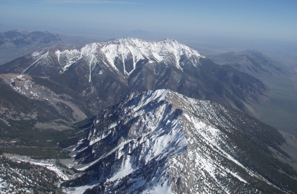
This photo was taken in late April while soaring above Sunset Ridge and looking South across Rams Horn Canyon towards the north flank of King Mountain. The vast expanse of the Snake River Plain can be seen in the distance.
Summer Soaring at King Mountain
Summer soaring conditions are marked by highs in the upper 80s (30c,) and lows near 50 (10c.) Summer has slower changing weather patterns with fronts generally tracking through on a 7 to 10 day frequency. Early June and early July tend to have more moisture. Late July and August tend to be hotter and dryer. Warm southerly or monsoonal flows will occasionally track up from California and the Gulf of Mexico. While more common earlier in the summer, these southerly flow patterns can last for a week or longer any time of the year. While much drying has occurred in their journey across California and Nevada, monsoonal flows are still generally associated with lower pressure and good buoyancy early in the day. Afternoon conditions can be overdeveloped with thunderstorms and localized gusting wind conditions resulting from outflow from the rain events. With cold fronts moving through, and shifts in the jet stream, these southerly flows are often replaced by westerly (zonal) or northwesterly flow patterns. The westerly winds aloft are generally associated with much higher atmospheric pressure and dryer conditions.

Here is a lovely shot taken in August just north of King Mountain looking north up Sunset Ridge. This day was very warm with surface highs in the mid 80’s and fairly high pressure at about 30.15” inches. Even with the high pressure, the Mackay Convergence Zone was producing beautiful cumulus cloud bases at 16,500 feet and cloud streets a hundred miles from east to west. The winds aloft were very light at less than 15 kts at 18,000’ feet.
King Mountain has tremendous high pressure soaring conditions, perhaps some of the best in the world, as the high altitude westerly facing ranges develop great amounts of heat and loft it into relatively cold air at the peaks. When the valleys are heat inverted and shut down in the summer, it is very common to see cloud streets with bases at 17,000 feet or more above all of the nearby mountain ranges. This can occur with atmospheric pressures as high as 30.40” inches! During these high pressure days when most folks are at home watering their lawn, King Mountain glider pilots will be at cloud base very happy to be wearing gloves and warm cloths.

High Desert Thermals
To get to cloud base during high pressure, Pilots will often encounter small and tightly wound thermals in the valleys and the lower soaring strata. These small core yet high velocity thermals will be powerful and punchy and require good centering techniques as they wind up through shear lines. Adjoining these fast bullets, will be generally one or two quadrants of turbulent or edgy texture. Steep bank angles and solid centering skills will be tested down low. Another feature these tightly wound thermals posses is strong terrain bias, in that various mountain ridge lines and orientations will create sweet spots while other ridges will offer up rowdy, turbulent, and unworkable thermals. Good soaring pilots will quickly discern this bias and move accordingly to the sweet spots. Conversely, we should not underestimate the ability of the ranges to generate very bad air on the wrong side of the ridges. Air texture can change rapidly and many open distance Hang Glider pilots can attest to the white water washing machine of being in the wrong place at the wrong time.

Often, many pilots flying the giant mountains will find better lift further out in front of the main ridge as thermals “trip” from lower knobs and ridge lines at or near the tree line. These knobs are often over 2000’ feet above the valley floor and in many parts of the world could be classified as mountains. These very workable thermals can be found by working lift lines upwind and over the knobs from the main ridge, or by just being patient and waiting above the knob.
The “knob” located just north and adjacent to Lower Launch on King Mountain is a prime example of such a powerful thermal generator. Get up above this awesome thermal generator and be ready to launch to cloud base above King Mountain.
The mid level soaring strata at King Mountain finds many thermal joining each other above the mountain forming much larger masses that can rise upward at tremendous rates. 20 kts is not uncommon. With the mountain at 10,780’ feet above sea level and cloud bases at 12,000’ to 18,000 feet or higher, use of supplemental oxygen becomes an important factor and should be considered once we climb above the main ranges.
Once we are in the higher strata nearing cloud base, long workable lift lines allowing high speed dauphin flying are very common. Hang Gliders and Paragliders along with lower performance sailplanes should always be wary of “cloud suck” when nearing these high cloud bases, especially when there is greater convective energy available. True airspeed will also increase with the thinner air at altitude, and coupled with tailwinds it is not uncommon to see very high groundspeeds. Cross country in these conditions has long blue jumps over the valleys with booming conditions along the ranges. 300 K Region 8 sailplane speed records have been set here during the summer, with a start point directly in front of King Mountain. The open distance Hang Gliding record past Bozeman Montana was also achieved in the summer at King. The flight was over 180 miles.

The Fall Weather Patterns at King.
After Labor Day, many folks believe that some of the best soaring arrives at King Mountain. Cool fall nights and sunny daytime highs into the 70s (25c) are the norm. Night time lows will dip near freezing and gorgeous “Indian Summer” days will stretch towards November. Lighter winds aloft prevail and cloud bases will generally still reside around 15,000’ feet. With little or no snow on the upper ranges, good afternoon heating occurs in the shorter days. Thermals above the ranges still reach 10 kts and cross country opportunities abound during a shorter window of time.
On October 1st of 2008, I was in a gaggle of 3 hang gliders and 2 Paragliders who launched from King Mountain. Flying a rigid wing hang glider, I climbed from launch to 15,000’ and dauphin flew west into light southwest winds aloft. Soaring under a beautiful cloud street forming on the southern edge of the Mackay Convergence I made it half way to Sun Valley before running out of sun. After lingering to enjoy the scenery above the Pioneer range and the high mountain lakes west of Copper Basin, I climbed and drifted eastward in a couple of late afternoon thermals. A long high speed final glide returned me back to King Mountain for a 60 mile out and back. Directly in front of lower launch, I hooked into the famous evening glass off conditions and began climbing again at 3 kts. Having my fill, I then glided back down to land at the Glider Park just before sunset.
Mountain Waves at King
Wave formations in this area are generally complex in structure, owing to the range and basin geography of multiple ridges having variable spacing. With strong winds aloft, those in excess of 30 knots at 12,000’ feet msl, mountain waves can form downwind of one range and can extend to and be amplified or dampened by subsequent ranges.

Here is a picture of the waves that can form over the Big Lost River Valley. We are looking northwest from the Glider Park. Also visible in the left side of this photo, are large cloud formations associated with the Mackay Convergence Zone which is stretching east towards the right side of the frame.

This photo was taken from the highway leaving the Craters of the Moon and looking east towards King Mountain about 10 miles away. Here we can see that King Mountain has an amplified standing wave forming on the windward side and exhibiting a very steep profile. This wave is formed by a 3000’ foot mountain just a few miles west of the Glider Park called Appendicitis Hill. On this day it appears to be amplified by the ridge lift in front of King Mountain. We can see that the wave is upwind of King as the afternoon sun is casting the clouds shadow to the east on the face of the mountain. Also visible beneath the standing wave, we can see a small rotor cloud being formed. With basic scaling and a valley floor at 5500’ feet above sea level, and the top of King at 10,780’ feet, we can see is this photo that this wave cloud extends well above 20,000’.
A few years back at the King Mountain Hang Gliding Championships, Joe Evans, flying a rigid wing glider, hooked into a similar wave above Saddle Peak on the South end of the Lemhi Range to climb to just under 18,000’. He then button hooked around the south side of the wave, to avoid the sink following the wave, and went on a glide to well past Dubois, Idaho. He then made a low save over the flats, and made it to goal at Henry’s lake for the longest flight of the day.

Here is a photo taken from Darlington, Idaho looking south east towards King Mountain just behind the power pole. This wave at the very top of the photo was also in front of King Mountain and was directly above the Glider Park for most of the day. The large rotor cloud also remained stationary beneath the linticular cloud even though the winds aloft were in excess of 30 knots.
While not always marked with lenticular clouds, wave formations can be used to find lift lines and thermal trip areas downwind of the huge ranges, in areas that most folks would believe only had sink. Look for lift lines forming leeward of the range about where the base of the mountain meets the valley floor as this is the general location of the primary wave.
I used this tripped effect during the first day of the 2008 hang gliding championships to find lee side thermals that were forming parallel and just a couple of miles down wind of Sunset Ridge and the Lemhi Ranges. Use of these mountain wave induced lee side thermals jump started an open distance cross country flight 103 miles towards Henrys Lake and Yellowstone National Park. No wave clouds were visible, yet small cumulus and good lift was being formed in the primary wave locations.

The Mountains Breath and Sometimes They Sneeze
Geography plays a powerful roll in soaring weather patterns throughout the region. King Mountain Anchors the South end of the Big Lost River Range with Idaho’s Tallest Mountain, Mt. Borah at the north end. This range averages 5000’ feet higher than the valleys on each side. This predominately north/south range then parallels another giant range to the east called the Lemhi Range. The next range about 40 Miles eat of King is the Bitterroot Range which also forms the Continental Divide and the Idaho/Montana border. To say that these giant north/south ranges have a strong influence on the soaring conditions in the region would be an understatement. Hot dry air from the Snake River Plain rises up these huge valleys in the day time. At night, the pattern reverses as cold snow capped air falls back down. This breathing pattern will often overpower prevailing winds aloft in the lower elevations and Pilots will encounter shear lines while climbing or descending through the strata.
Night Wind

Here is a panoramic view from the top of Coyote. Almost every morning at sunrise we will find an 8 to 12 kt breeze flowing down the valley from the north. Hang Gliders and Paragliders will often be at the Coyote Launch to ridge soar this catabatic flow as it rises up the NW flank of the Arco Range.
Day Wind
 The Snake River Basin to our south is desert and covered with dark black basalt lava flows. This giant hot plate heats in the summer sun, which is then funned into, and then convects northward into the high valleys. In addition, the high Ranges also are being heated and are releasing giant thermals for which King is so famous. These two forces combine to form a strong valley wind. By 11:00 AM it is common for the wind to be out of the south at the Glider Park. Some time later around 1:00 or 2:00 PM it will be out of the south at the Mackay Airport. This southerly wind will average 12 to 15 kts and will continue until sunset when the night breeze once again begins.

The Big Sneeze Outflow events from large cells should watched very closely. It is common for strong wind and gust fronts from rain showers located over Mackay to extend as far south as Arco 20 miles distant. These events will overpower the normal day breeze up the valley. Watch for blowing dust which indicates gust fronts and surface winds exceeding 30 kts.
One time while soaring over King on a Hang Glider, I observed the gust front approaching the Glider Park from the North. This strong outflow was being created by a large cell and rain storm over Mt. Mcaleb just east of Mackay. Rather than attempt to land in these conditions, I chose to find a safe haven and wait it out. The NW flank of King proved an ideal place to hold using the outflow energy and ample altitude to buy time. The winds aloft we fairly light that day so it took some time before the cell moved on to the next valley east of Mackay. About an hour after the first strong gusts came through, the winds were still out of the north, but now only 8 to 10 knots, making for a much safer landing at the Glider Park.
The Mackay Convergence Zone
The Big Lost River Valley, along with the Little Lost, and the Birch Creek valley, along with the giant Snake River Plain, all generally flow towards the north during the day. At their summits, these basins meet other giant valleys which slope the other direction. These valleys sloping upward to the south would include the mighty Salmon River drainages, along with the Pahsimeroi, Leadore Creek, and all of the Montana drainages that feed the Missouri River on the other side of the Continental Divide. As these giant rivers of hot air collide, they often form a powerful line of convergence which often forms 15 to 20 miles north of King Mountain. We have named this phenomenon the Mackay Convergence Zone. The cells which create the outflow sneeze effect often form along this line.

The Mackay Convergence Zone often stretches from Sun Valley, which is 50 miles west of us, to Manida Pass and the Yellowstone Country over 100 miles to the east. Many Pilots have used this line of convergence to their advantage. Many others have been blocked by the overdevelopment which can be common with higher atmospheric moisture and lower pressure which can also accompany southerly flow patterns. 3 of the 4 open distance routes used in the Hang Gliding Championships cross this vast line of anabatic convergence. Often during the summer months, a surface stationary front is depicted near this area, with a noticeably different air mass having higher relative humidity located north of the line. A dryer air mass is often located over the Snake River Plain and Deserts. This can create a smaller yet very similar effect as the “Dry Line” associated with Texas, Oklahoma and the Midwest.

A great NASA shot looking west. The faint snow lines are visible at the valley summits.
On one occasion at the Hang Gliding Championships, while waiting for my driver in the Centennial Valley just west of Yellowstone, I observed this line of convergence over Manida Pass and the Centennial Range of the Continental Divide. The convergence cycled three times from a beautiful cloud street, to a solid line of Virga clouds, to overdevelopment and rain showers, and back again into blue sky. During the next days pilot meeting, Bill Soderquest the winner of the championship that year, referred to this effect as opportunity “windows” which can open and close. My standing on the ground, rather than flying further towards goal, was the outcome of not timing this effect correctly.
Another observed effect from the Mackay Convergence is high clouds streaming downwind from the tops of the cells. These high clouds will shadow the sun for many miles distant from the actual convergence itself. This effect is very dramatically felt in the summer afternoons when the sun is located in the NW sky. These are the days when traditional glider launching times between 2:00 to 3:00 PM may be to late. Earlier launches in the noon time frame will often find great conditions. Another possibility is to wait until the overdevelopment ends in the evening and fly the outstanding glass conditions which can form over the range.
On the last day of the 2008 Championships an early day was forecast with high CAPE values and a southwesterly flow aloft. Most folks managed to get of launch early but I was working with a new camera mount for a PBS program about Hang Gliding at King. Most of the other folks who had waited to long to get off from King found huge cloud shadows shutting everything down. With the camera gear finally installed I patiently waited and enjoyed the scene as the cloud cover slowly moved by. At 5:30 PM in the evening the skys once again cleared and a couple of us launched in the fresh sun and lift that had now reformed over King. It was like a new day as I jumped east over the Town of Howe and moved with thermals forming over the Snake River Plain. Following Highway 22, I drifted past 4 corners and landed just east of the Cement Plant for about 50 miles and some awesome video footage in the liquid evening light.
The Snake River Plain
On days with ample moisture and latent heat exists in the atmosphere, otherwise known as Convective Available Potential Energy or CAPE, early starts and prompt crossing of the Mackay Convergence Zone can help the pilot realize great gains. Late starts will often be met with shorter flights as the routes to the north and east can get shut down.
 Here is a shot taken a few miles south of the Arco Airport or about 10 mile south of King Mountain. We are looking west towards Craters of the Moon. The vast expanse of the Snake River Plain can be seen in the left. This is the giant hot area that funnels into the Big Lost River Valley and towards King Mountain during the day. Virga and showers are over the higher mountainous terrain can be seen to the right. This is a great example of how we can use the diverse terrain to avoid the overdevelopment and have a great soaring flight. Directly up the cloud street towards the west are the airports at Carey, and Picabo just south of Sun Valley. Experienced Sailplane pilots will often use this edge effect and shift their tasks to the Snake River Plain when mountain over development occurs.
The Hang Glider Championships have a route which heads south towards the Big Southern Butte, into the Snake River Plain, and beyond towards the Wasatch Range of Utah.


Air, Water, and Ice….a Physiological Supplement

Oxygen is required for survival. Using a good supplemental oxygen system is essential when soaring in this region. The FAA require oxygen for aircraft pilots anytime they are above 12,500’ feet for more than 30 minutes. Many experienced pilots will use it when they are above 10,000’ feet. With all of the mountain ranges in the region standing higher than 10,000’ feet above sea level, common sense dictates that we use supplemental oxygen anytime we are higher than the mountains. Sailplane pilots who fly the area each summer will not tow up without it, yet many Hang glider and Paraglider pilots incorrectly consider the use of oxygen as optional. A good light weight, long lasting, and portable system with automatic metering is available from Mountain High Oxygen.
Water is also an essential element when flying in this dry region. Dehydration will disable us both mentally and physically. When using water be aware that lines can freeze at high altitude. Regular use of a water supply will keep warmer water flowing and lines open. A personal technique developed over the years is to use oxygen when climbing and water on glide. For energy, I also fly with small snacks as a reward for a low save, or something to do while waiting for my driver to find me.

Hypothermia from exposure to the cold is also both physically and mentally disabling. The air is very dry in the west. The air has to become very cold before it become visible. Unlike the Midwest and Coastal areas, cloud base in the west is generally at the freezing level. Wind chill when Hang Gliding or Paragliding can be extreme. Warm gloves or bar mitts are a must.
Prolonged flights in a sailplane can also be very cold, especially when under cloud shadows. Dress very well even in the summer. Imagine you will be skiing and dress accordingly. Many of us believe that if we are not sweating on launch or in the cockpit we are not dressed warm enough for high mountain soaring at King Mountain.