Finding Wisdom…by Paul Allen July 1, 2010 The lady behind the bar looked me over skeptically. I was dripping mud on her already muddied floor.Though too old to make it work, I tried my boyish grin. “Sorry”.She scowled. “Which ditch did you crawl out of?” came her not buyin any of it response.Truth was, I HAD just crawled out of somebody’s ditch. Wisdom, Montana is possessed of a classic white church with bell tower surrounded by a few dozen houses, a Sinclair station, Fetty’s Bar/restaurant, and a mercantile. There is no cell phone service in the Big Hole valley so I had had to hitch here to find a land line.“I’d like to pay you for a long distance call” I asked. She pulled a chorded phone from beneith the bar and turned her attentions to some raucous locals.There was no answer so I left a message as to my whereabouts and sat down.The woman returned, clearly disappaointed that I was still there, muddying her floor. She wiped the bar in one motion and slid me the menu. Nothing looked interesting but I was soon informed that the kitchen was closing and that all they were serving was “the Special”. Why the menu, I wondered. I ordered “the Special” which turned out to be a pretty OK reuben with home made soup. I read the paper placemat while bar maid studiously ignored me. Wisdom was named after the Wisdom River; so called by Lewis and Clark for one of the noble traits recognized in their benefactor Thomas Jefferson. The River was later renamed The Big Hole, but the town, which now holds over 100 persons, kept its quixotic name. The US Calvary nearly anihilated the Nez Perce here in 1877 in the Battle of the Big Hole. Today, the town was my refuge from mud and hoards of mosquitos. Five hours of grueling mountain flying had brought me to the continental divide at 17,000′ above Lemhi pass. Snow clad peaks girded the Montana/Idaho border like so many Nez Perce sentinals. The mountain snows trickled life giving melt to a sea of lush grass that extended nearly out of sight to the east. Classic Big Sky country. Cold had crippled my radio but my position was recently known and I was laying bread crumbs with a SPOT Locator. I drifted into lands where one’s spit flows to the Atlantic. Eventually the woman returned to collect my plate and warmed slightly when she found that I intended to pay my bill. She asked about the mud and the abundance of welts on my face and I told her thusly my truth: “Your town is but an island”, I observed. “An island in a vast lake,” She didn’t argue. “Your grass is but a disguise to entice the unwary aviator.” “Your hoards of mosquitos have met out justice for my lifetime of sins.” “Your mud has humbled me and my once proud sky ship: “Be this Purgatory?” “No”, she said. “This is the place of Wisdom”
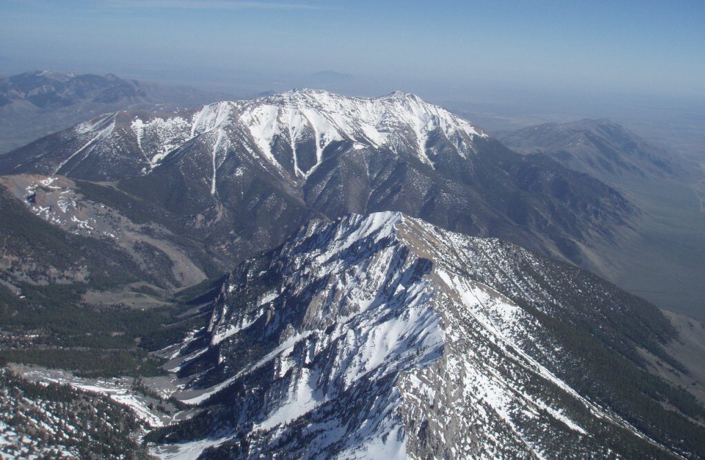
Saddle Peak and the Lemhi Range looking north in the Winter
We had many Cu’s as soon as 10:30am, and the operation started around 1pm. The cloudbase was a bit low (14,000 ft and 15,000 ft in some places) considering the hight of ridges (11,000 ft to 13,000 ft) , we had pretty good flights. I went north following the ridge in which King Mountain is part of, turned south, then jumped to a mountain area west of it. I flew over Sun Valley, headed as south as the mountains took me, and headed east to go home.
Thought most of the flight was over mountains, there were many good airports to landout. I liked the path I took for coming back from west. Because the straight line to King Mountain goes between two hills, I did not need add an extra altitude to what computer said to fly over a ridge. There are a couple of airports you can safely landout if you were to low to make it to King Mountain. Also, small hills around King Mountain were generating 2 to 3 kts of lift very late. It was very friendly way back home. For more soaring storys by Gen Shibayama, see his soaring blog at http://genssoaring.blogspot.com/search?updated-min=2009-01-01T00%3A00%3A00-08%3A00&updated-max=2010-01-01T00%3A00%3A00-08%3A00&max-results=50
Today was the first day at King Mountain Glider Park for me, and the first day of operation for King Mountain Glider Park. John Kangas, his family, and his staffs spend three years to put this place together…Gen Shibayama
Gen’ s video of the first sailplane being towed at King Mountain. Tow Pilot-Hank Butzel in Piper Pawnee, Glider Pilots-Matt Gillis and Ron Hess in DG1000.
Three 500K flights in one week at King…
Ramy and Katia at 2009 Inaugural Safari (Photo by Trond Byornard)
Thanks John for the well organized event. I really enjoyed flying at King and am planning to come back again.
As someone who is hungry for distance, this site did not disapoint me for distance potential and scenery. The scenery is one of the best I had seen, and I am flying all over the country. I averaged nearly 500km per flight in 3 flights, the longest being 636km to Yellowstone park and return.
CHASIN’ FRANK No matter whether we’ve known it or not, we’ve all been chasing Frank for a long time. Frank Gillette’s always been the flying icon to aspire to, the hero of our flying, he’s been around longer than anyone else, longer than the trees. I first flew with him in 1978 at the Riggins Idaho Fly In, and over the years have realized what large shoes those were to step into. His Idaho State Record has been equally difficult to surpass, and every year that has gone by, we all realize more and more what an accomplishment that was back almost a decade ago. Moreso, even four years after the advent of rigids, he was still on top, untouchable; try as we might, we couldn’t even come close to the bar he set for us to fly over. So it is with a measure of both pride and humility that I recount the following flight, because in the yeoman’s effort to raise the bar a notch for the region, I am acutely aware of the size of shoes that I am sticking my toes into. Friday, July 14, 2000. The day had some of the ingredients I wanted to see: there was a wide temperature spread predicted, 40’s at night to high 90’s during the day, so it would be unstable. It was dry, so cloudbase would be high. Dust devils abounded early on launch. But then high cirroform clouds started pushing in from the southwest, and no cu’s were developing near launch. What the heck, we’re here: Ken Cavanaugh launched first, followed by Eiji Yakoda, I was third clocking in at 1:25, Dave Kriner fourth, all in the air within 15 minutes. Climb out was tedious, the King Mt we know and love; I pulled out of the squirrely lift at 11,300′ and flew over to Rams Horn canyon, Ken and Eiji along with me, Dave lingering back. Still no clouds nearby, a few well to our north, high and ragged. Hmmm. We climbed some in the canyon, to 12,000′, but I wanted to see if it was more unstable to the north, so I pushed on down the ridge. The numbers aloft had indicated the Ruby Route; Ken had said on the way up that on this route, he didn’t like to go over the back past the middle of Sunset Ridge, and there is much merit to this, as it is the highest point of the ridge, there is a secondary ridge that extends to the east off the backside to mute the rotor, and it is the nearest point to the Lemhis.
Well, none of this mattered anymore; I was getting drilled out in front of Sunset. Chairman Mao said that “the longest journey begins with the first step”, but my journey was ending before it started! While Ken and Eiji were fighting it out and slowly climbing still at Rams Horn Canyon, I was heading out over the foothills of Sunset for a landing. Down to 8600′ I zero sank for awhile; it eventually built and got me back in the saddle up to 11,500′. Persistently I pushed north, looking again at those ragged cu clouds on the range across from Mackay. But it got worse. As I slowly dribbled north in the weak conditions against a now quartering headwind, Eiji then Ken started to go over the back from the canyon at 14,300′. But not me; I was plowing lower and lower. Down to 9,600′ at Pass Creek I radioed that I’ll try to get up and over at the pass, but was not having much luck. The venturi at the Pass was full on, I rocked and rolled through red rocks and the foothills before Invisible Mt., and finally got around the corner and started a light climbout. I skated past Invisible now at 10,500′, and on the next peak to the north, WOW ITS HERE!! Holy Smokes right where the ragged clouds just started to begin, the lift was thermonuclear. I eased my Laminar deeper and deeper into the violent column until I was full on at 1350 fpm on the averager, 60 degree bank, gripping and ripping, drifting back with the climb, ah yes I recognize this!! I staircased it; I was too scared to go straight over the back, this being the widest possible and most formidable point of the range for a crossing, so out in front again at 13,500′, thermalled back, out in front again at 16,000′, and calmly told myself that this was it, the one, you were over the back with its drift, so get into that zone of tracking, ignore the fact that you forgot your bar mitts and can’t feel your gloved fingers, you need altitude and drift. Ever so careful not to exceed 17,999′, I radioed to the surprised Driver Toni in Howe that I was over the back north of Invisible. Yahoo!!! I had finally taken the first step in the long journey.
I drew a bead on Bell. It looks like the Grand Teton from the distance and ever moreso up close. I had a tailwind component of about 18 mph, picked up a little zero in the center of the valley, and moved to Bell as if on laser track with a ground speed of 62 mph. With no cu’s for the crossing, I was intent to get where there might be better lift; there was a cu on Bell and to its north, so I had reasonable hopes, though it takes a long time to fly the 25 miles to Bell, even at 62 mph. I aimed for the north shoulder of Bell’s canyon, figuring the dying cu would have ripped from the obvious rock scree there, and maybe I could get on that train. But I was too late, I only got the trash of its departure, gaining 1200′ up to 11,300′ in the swirls and eddies. Radio reports from the guys weren’t good: Ken and Dave had landed over the back of King, and Eiji was going to land imminently. I was acutely aware that the best of flights can be stopped so fast; that the ingredients to a long flight include getting through all the bottlenecks, and I was at one: lift would be no good out in the valley, so I stayed deep against Bell and flew to its south shoulder to pick up apparent windward southerlies that were indicated as valley flow. That worked, a thermal came up the ridge, I eased my way back with it across the impressive face of Bell, and off the north side with the drift. The next peak to the north and deeper on the range was producing; I eased over to it in the drift, and pulled up to 15,500′. The lift was broken, but I was glad for no more altitude, my hands were still numb from that first climb out, 15 and change would be fine. I radioed my position and drew a bead on the Bitterroots.
I was chasing the cu’s. What few were there were out in front of me still, only an infrequent lost cu nearby. My target on the Bitterroots was the large brown peak with no trees on it, the highest point along my route of travel. Down to 12,000′, I was struggling to find something on the front side of this peak; but to its north and fairly deep into it, I found steady lift and with the drift made the decision to go over the Divide at 13,000′. Still climbing at 16,600′ on the backside, I radioed my position as over the Bitterroots, and the fuzz on the return was the last I heard from my team mates for the next eight hours. I was completely on my own; it was 4 pm.
East of the Divide was where all the cu’s were gathered, skittering over the range and hiding in Montana, those sly dogs. But even though I had 80% cloud cover, little was working. I smiled when I could make out Ellis mountain to the north on the Tendoys; I recalled a 116 miler I had from there in my first Grant Fly In, 1989. I knew the way from there! So in the weak conditions, I worked my way north toward the Tendoys and Ellis, flghting to hold altitude. But down to 13,500′ 2 miles south of Ellis Peak, I had to stay with weak lift and get back to something that would enable a crossing of the Tendoys. I drifted east of Ellis over the range at 14,500′, and lined myself up with the east side of Clarks Canyon reservoir. But little was working with the overcast; I was really trying to stay in the air, and was just barely.
Just south and east of the reservoir, I picked up a light thermal at 12,500′, and told myself to get back into that zone of drift, this was the only game in town, and I needed the drift and altitude for the next crossing of no-mans’ land on the way to the Ruby’s. I spent a lot of time in this light lift, and at 15,600′ it occurred to me that there was no discernable core, that the area was all gentle lift. I was high enough to get to the Ruby’s, and while still trying to get my right hand warm, I drew a bead on the front of that range. The sky was now 90+% overcast, but there was a street in the cast that pointed exactly where I was going. This never happens!! From 15,600′, I never made another turn for 34 miles!! My altitude changed from 15,600′ to 17,300′, and back down to the low 16’s by the time the end of the range came up. What a fantastic ride, groundspeed a steady 60-62 with the 18mph tailwind, but I was soo sooooo cold, my right hand now a frozen claw that I had to push into the front of my harness for bits of time, my whole body shuddering with hypothermia. Oh the joy and the pain!!
The deeper I got onto the Ruby’s, verga surrounded me more and more. Aside from the cold, I didn’t want to get any higher because of the overdevelopment. At the end of the range, there was a wall of verga; this completed a horseshoe around me, and even though at 16,000′, I started to think the flight was over. Indeed I plunged into the verga on course line and fell 5,000′ in the blinding snowstorm. Out the other side, still 100% overcast, I was looking for a place to land: the massive Tobacco Root Mountains were to my north, Sheridan at their base 5 miles to my west, Twin Bridges to its west a few miles further. Twin Bridges was my goal call, and it would be an easy glide in the quartering headwind to get to the airport, a nice 132 mile declared goal. I looked on my course line to the northeast, and there was no way to get over that no man’s land on the east slope of the Tobacco Roots with my altitude. I looked to the east, and there was Virginia City beckoning with some nice fields. Then I remembered something Rich Pfeiffer told me a long time ago in his more lucid days: that you make the decision to land, most often subconsciously, long before you actually land. That you essentially predispose your decision, and your actions lead to landing; whereas if you make the decision to stay up, you would make different decisions long before in the flight. I needed different decisions, landing was not one of them: so on the east side of the Tobacco Roots, in the 100% overcast, I went into search mode for any lightest area of lift that I could trickle with and drift over the range and over the no man’s land and to a green field I could see far to my northeast. I found the lift, and amongst the gentle swirling snow verga falling on the Roots, circling for the next half hour, I pulled back up to 15,500′, and was back in the saddle again.
The hard parts of the flight were done, I was essentially over flat land/rolling hills; but unfortunately it was late and the day was also pretty well done. Hwy 287 north of Norris was a welcome sight, I was down to 10,000′ and it looked to be final glide. Land along the highway?? North now of the highway, out of curiosity, I punched up the “Go To” on my GPS, hit King Mt, and it read 165 miles!! Yahoo, I had it! My mind switched to the next goal, my longest flight, which was 177 miles, just done in Sandia two weeks earlier. Heck with landing. I went into full search mode again, and found a little weak area in partial sun that was going up at 100 fpm. I centered in this and treated it like my last possible thermal, getting to 13,200′ before it finally petered out. It had nice drift, and placed me within easy glide of Amsterdam/Churchhill.
There was the Interstate, there was Bozeman, wow its all so near now. But cloud cover was back to 90-100%, and I was on final final glide, I knew it from 11,000′. I overflew Belgrade, thinking hard now about witnesses as well as realistic LZ’s, down to 9,800′. But there was Felix Canyon in front of me, a hang gliding site on the Bridgers I had flown with Will Lanier and some of the other Bozeman pilots years ago. There was significant verga at the north end of the canyon, and also to my east on the Bridgers. The party was over, my task was to stretch the glide to the canyon road, and land where there were witnesses and where my crew could find me. At the end of the canyon, 17 miles north of Belgrade, with rain two miles in front of me, I circled the final 2000′ down to a sunburnt barley field, and landed prettily back to the south in zero ground wind. It was 7:20, 5 hrs 55 minutes from launch, 187 miles reading happily on the GPS.
Two ranchhands working the field nearby saw my approach and landing, and offered all assistance. They took me to their ranch house two miles away to make the call to Ken’s home phone, I called in my position, then they fed me a huge dinner and drove me back to my gear to break down before dark. We hauled the glider and gear back to the ranchhouse to wait for our gang. Ken had gotten my message that I was over the back of the Bitterroots, so they all knew I was east of the Divide, but didn’t know where. They stopped in Lima, MT, thinking that I could be up one of the many canyons there. So they were a long way out by the time I called, and arrived at midnight jazzed but sleepy at the ranch. We drove back all night, and got back home by 0800 the next day. What an epic retrieve, equal to the epic flight, and my deepest thanks to all who put in that long night.